NASA's Perseverance Mars Rover
- • 100%Featured
Curiosity on Lemmy!
I would like to announce our "sister" Lemmy Community About Curiosity who is roaming Gale Crater since 2012. !curiosityrover@lemmy.world
4-tile end-of-drive NavCam. The terrain in front of the rover (small pebbles) in the sand, is often a good sign of reasonable driving conditions. We're not too far from "Dox Castle" (a possible science waypoint), so we may see the rover change course soon.
Awaiting the post drive data (JSON) and official map
Episode 180 Last month, Perseverance began an epic climb up the rim of Jezero crater to explore new science targets on the outside. After three weeks and ten drives, Perseverance was only about a tenth of the way up. But then something changed.
No, I'm not calling this a "potential biosignature" 😆
Mars Guy has documented some of the rover team's prior work on coated rocks, although I don't remember seeing any examples this visually striking.
The coated rocks which have been documented prior to this one - none of which were nearly so patchy as this one, if I recall correctly - have been interpreted as a relatively thick dust coating formed by the action of water vapor, i.e. humidity. Mars should have had some fairly recent episodes of higher atmospheric moisture caused by the tilting of Mars' axis, which would expose the polar caps to more sunlight and temporarily humidify the atmosphere while the ice is being redistributed to the new polar latitudes.
We've never had any mission climb the rim of a crater as large as Jezero before... not on Mars, or even on Luna... I'd say it's been pretty fun so far!
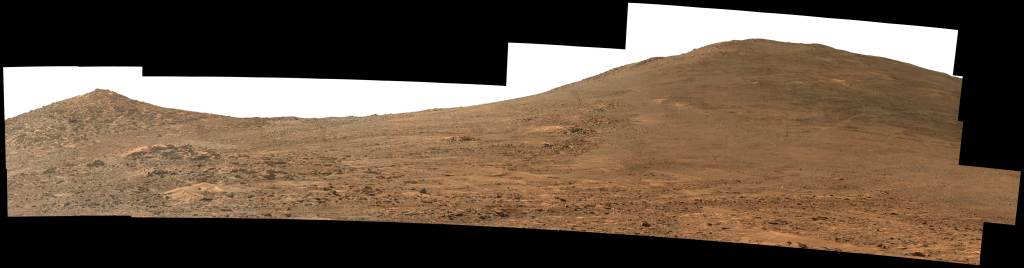
The climb continues with another good drive/climb during sol 1268. The views from this record elevation are a little spoiled by elevated dust levels. Let's hope the dust subsides a little before the rover drives out of the crater. NASA/JPL-Caltech/MSSS
4-tile NavCam - Looking back downslope after a climb of 20.36 meters (66.8 ft)
Screen shots from the official map - https://mars.nasa.gov/maps/location/?mission=M20
Data acquired from JPL's JSON feeds
Max Zoom - looking East. Harsh processing to address overexposure of the raw image
This view was created by plotting an estimated former lake level derived from putative paleolake-shorelines and the upper delta-top boundary. The Jezero crater lake must have been filled with water even more to overcome the swell of the Pliva Vallis outflow channel. The view was created by ESA using their images and those from NASA (see credits)
I have added the estimated location of the rover on sol 1265 (current position)
Image: HiRISE/CTX/HRSC - Credits: ESA/DLR/FU-BERLIN/NASA/JPL-Caltech/MSSS/University of Arizona
The drive took the rover over exposed bedrock, this greatly improves traction on the slopes of the crater rim. The rover dropped downslope 2.5 meters (8.1 feet) during the drive, and has joined one of the alternate notional paths that will take it out of the crater, and could see it have an easier climb to reach the next science waypoint. The view in this 4-tile NavCam is centered on the East, the large hill is obscuring the view towards the helicopter, Ingenuity is ~1420 meters (4856 ft) due east of the rover's location at site 59.1204.
6-tile L-NavCam cropped mosaic, looking back at the climb out of the valley.
Drive distance: 35.4 meters (116.2 feet). Climb 10.46 meters: (34.3 feet). Distance to Helicopter: 1488.8 meters (4884.5 feet).
Credits: ESA/DLR/FU-BERLIN/NASA/JPL-Caltech/MSSS/University of Arizona
Note the downslope drive.
All the data is from JPL's JSON URL feeds, but presented in this table.
NASA/JPL-Caltech/UofA
NASA/JPL-Caltech
A little known feature of Perseverance is its two LEDs that emit UV light. They’re used to search for fluorescent minerals, like ones on Earth that produce strange colors in response to UV wavelengths. Now, it may have found some.
R-NavCam tile shows the latest abrasion patch on Mars.
Image acquired earlier today
NASA/JPL-Caltech
Episode 178 Mars rovers have a habit of picking up rocks in their open wheels and carrying them long distances. The latest Perseverance hitchhiker came on board three months ago and rode along for nearly 2 kilometers (~1.2 miles). But then the going got tough.
Mars Guy is Arizona State University associate research professor Dr. Steve Ruff, a Mars geologist with decades of experience exploring the red planet. This channel follows the exploration of Jezero crater by the Perseverance rover and Ingenuity helicopter, presenting science, engineering, and the search for life on Mars using a novel in-person experience.
The contour lines on this map are spaced 10 meters apart (32.8 feet)
We've got a lot of climbing ahead to traverse out of the crater.
Bright Angel is at the upper center of the map, it can be distinguished by its lighter tone compared with the darker surrounding bedrock and regolith
Image: HiRISE/CTX/HRSC HRSC: ESA/DLR/FU-BERLIN, CC BY-SA 3.0 IGO CTX: NASA/JPL-Caltech/MSSS HiRISE: NASA/JPL/University of Arizona
This data is imported from JPL's JSON feed. JPL updates the JSON feeds after each drive
Tiled front left HazCam:
Looking SSE and uphill after the drive of 17.6 meters (57.75 ft) during sol 1254.
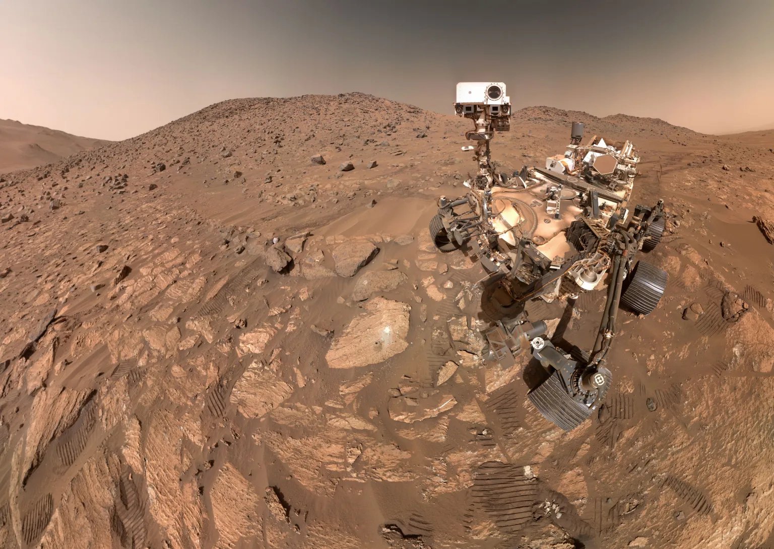
Stitched together by James Sorenson from 12 overlapping tiles (view full screen for the details)
Credits - NASA/JPL-Caltech/James Sorenson
There was a 3 meter drive on 1253, the rear NavCam after that drive showed lots of wheel-slip in the soft regolith. We can interpret the wheel tracks in this 1254 post drive NavCam (6 tiles), it indicates the rover reversed away from the 1253 waypoint and drove onto this rocky region. I estimate the point-to-point distance between the waypoints is less than 20 meters. The rocky terrain should provide much better traction for the climb compared with the soft sandy regolith that appears to have terminated the 1253 drive early. As a bonus the new location also presents a nice robotic arm workspace, if they decide to check out the rocks just in front of the rover before the next drive.
End-of-drive tiled NavCam (4 tiles)
Credits: NASA/JPL-Caltech
- science.nasa.gov Perseverance Kicks off the Crater Rim Campaign! - NASA Science
Perseverance is officially headed into a new phase of scientific investigation on the Jezero Crater rim!
Approximate locations of Perseverance rover and its sidekick Ingenuity helicopter during Sol 1250 (August 26, 2024). The view is looking due west, and shows the rover climbing up towards the crater rim after completing science activities in Neretva Vallis. The location of the helicopter is shown in final resting place after flight 72.
Image credits: HRSC: ESA/DLR/FU-BERLIN, CC BY-SA 3.0 IGO CTX: NASA/JPL-Caltech/MSSS HiRISE: NASA/JPL/University of Arizona
North is up
End-of-drive tiled NavCam
- www.nasaspaceflight.com Perseverance faces steepest climb yet, begins fifth science campaign - NASASpaceFlight.com
NASA’s Perseverance Mars rover arrived at the red planet in February 2021. Since then, the…
In 2018, NASA selected Jezero crater as the landing site for the Perseverance rover because it was thought to be the best place to search for evidence of life on Mars. So why after 3 ½ years of exploration has NASA decided to exit Jezero crater?
Visit the JPL interactive mission map for the up-to-date version
https://mars.nasa.gov/maps/location/?mission=M20
data from JPL's JSON feeds (updated after every drive)
The rover climbed ~19 meters (~62 ft) Image is a post drive 4- tile NavCam at site 56.5250.
Note the wheel tracks behind the rover
Bright Angel (sample area) can be seen on the far bank of Neretva Vallis.