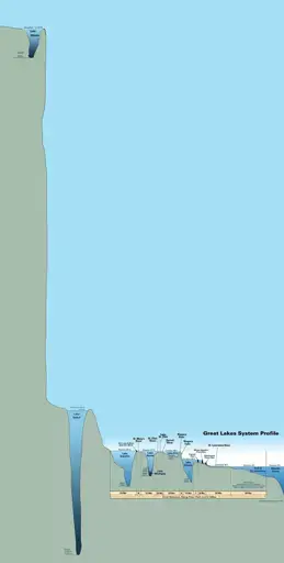
Lake depths and heights
Lake depths and heights


Lake depths and heights


W..where's the hidden Saddam Hussein‽
The internet has ruined me to the point I'm looking for either Saddam or Loss.
Are you ever gonna give it up?
@aihorde@lemmy.dbzer0.com draw for me a comic in the style of Loss featuring Saddam Hussein.
This map bothers me as they omit Lake Tahoe, which is higher than Baikal (6,200 ft) and deeper than everything except Baikal (1,600 ft deep)
What's the point of including all that empty space between Baikal and Titicaca when there's a world renowned lake that would be great to include
The map makes absolutely no sense to 97% of the planet and that's what bothers you? 😂
This was originally just a map of the Great Lakes system. Someone added Baikal and Titicaca to it later for comparison.
So you’re saying it’s not really special. Not the highest, not the deepest?
Sure. Throw it in!
TIL! Maybe Crater Lake too.
Crater Lake, Lake Tahoe, and Lake Chelan.
Why is lake Baikal the only one with measurements in meters?
Feels like the map maker made a half-hearted attempt and just gave up after the first one.
You mean the second one
Who builds a lake on a cliff?
Why bother making this at all if it's not to scale? Sure, nobody expects the horizontal scale to be the same as the vertical scale. Vertical exaggeration is common when displaying profiles or cross sections, but those are generally still considered to be at a particular scale. But, if the vertical scale isn't consistent, then what even is the point of the graphic? Just list some numbers in a table. Putting this in graphical form without a consistent scale is just lying and lazy.
You don't seem too enthusiastic about this map.
No metric either, and only 2 non-american lakes.
It looks like these are two separate graphics spliced together, everything on the right seems to be to scale (or reasonably close to it)
I didn't break out the ruler or anything, just going off of the pixelated disclaimer at the bottom.
Heh. Titicaca.

Don't accidentally drop your phone in Lake Baikal. You'll never get it back.
Bolivia is weird.
Missed opportunity to include the dead sea.
My favorite lake is the Pacific. Its like the king of the lakes.
Hey, what about this...!
Why is Lake Michigan combined with Lake Huron when all the other lakes are individual?
It's the same body of water, one lake. It's just massive, and surrounds the lower peninsula of Michigan, so they gave each side of the lake a different name.
Truly it's massive, it behaves almost like the ocean in a lot of ways. A lot of water.
Wow, no way! I thought the part between the UP and LP was a lot narrower than it is! Never realized that it was just one big lake with a narrow part
The waves on Lake Michigan were far larger than I expected when I visited. Not as high as the Atlantic or Pacific, but pretty big.
Huron and Michigan are hydrologically a single lake because the flow of water through the straits keeps their water levels in overall equilibrium.
I thought this was going to be another Saddam Hussain meme, at first glance.
It's not my work + I didn't think of it
Lots of criticisms but still really cool. I'd love to see one to scale as well (for width and depth)