
OpenStreetMap community
- • 95%weeklyosm.eu weeklyOSM 738
05/09/2024-11/09/2024 Data structure, graph theory, control element but also OSM! [1] | © xkcd About us Bastian Greshake-Tzovaras has started using weeklyOSM to practice their Spanish. darkonus mar…

Some really cool transit map generation from OSM data. There's an online demo you can play with here.
One shows only a few shops, often the ones that pay the most, the other shows the true number of different places in the area.
@osmand why are you so slow? this is a brand new samsung galaxy s24+
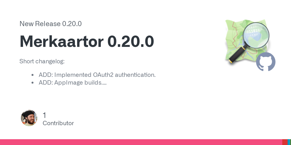
- github.com Release Merkaartor 0.20.0 · openstreetmap/merkaartor
Short changelog: ADD: Implemented OAuth2 authentication. ADD: AppImage builds. FIX: Fixed CI builds. FIX: libproxy and libgps external library handling by build system. FIX: CMake unity builds. FI...
@openstreetmap Is there any documentation on mapping individual small plants like flowers or cacti? I'd like to start mapping botanical gardens but cannot find any information on this.
- • 97%weeklyosm.eu weeklyOSM 737
29/08/2024-04/09/2024 Tricks and tips on how to draw buildings [1] | © Koreller | Map data © OpenStreetMap contributors Mapping [1] Koreller showed us a series of tricks and tips on drawing buildin…
Das Atomium in #Brüssel, gerendert in #cgeo auf der 3D #OpenStreetMap #Freizeitkarte sieht lustig aus.
cross-posted from: https://discuss.tchncs.de/post/21076796
> xkcd #2977: Three Kinds of Research > > alt text: > > > The secret fourth kind is 'we applied a standard theory to their map of every tree and got some suspicious results.' > > https://explainxkcd.com/2977/
Hi is there some project, instructions or some github repo for converting 360° video and GPX file to something like street view?
I would like to map this way local cycling routes.
I have recently got into mapping traffic signs and speed limits where I can, but I realised I don't know what to do when mapping differing speed limit signs that are offset from each other. It's a transition from a 50km/h zone to a 60km/h zone but the signs are offset by 65m, making a sort of "no-mans land" in-between. I plan to map it with the in-between zone tagged with separate
maxspeed:forwardandmaxspeed:backwardtags. I assume it should be done this way because as a driver on the ground I would follow the speed limit signs on my side of the road as I passed them, having no knowledge of the reverse sign.I guess I'm wondering if this is a logical way to map this?
I recently got a Pixel and installed GrapheneOS on it. I would like to add some places to the map. Is there anything I need to know regarding preserving my privacy while contributing?
Thank you for any advice.
It's a key feature of Google maps that I don't have a great replacement for. I assume moderating the reviews would be a significant challenge for the project.
- social.lol Henry (@hl@social.lol)
Attached: 2 images Glad to see the great job @openstreetmap@en.osm.town and @organicmaps@fosstodon.org are doing. For cycling to the zoo's main entrance, where I can buy entry, they suggest a sensible route. #Google maps seems to suggest I go through the zoo, possibly via the tiger cage. #OSM #Op...
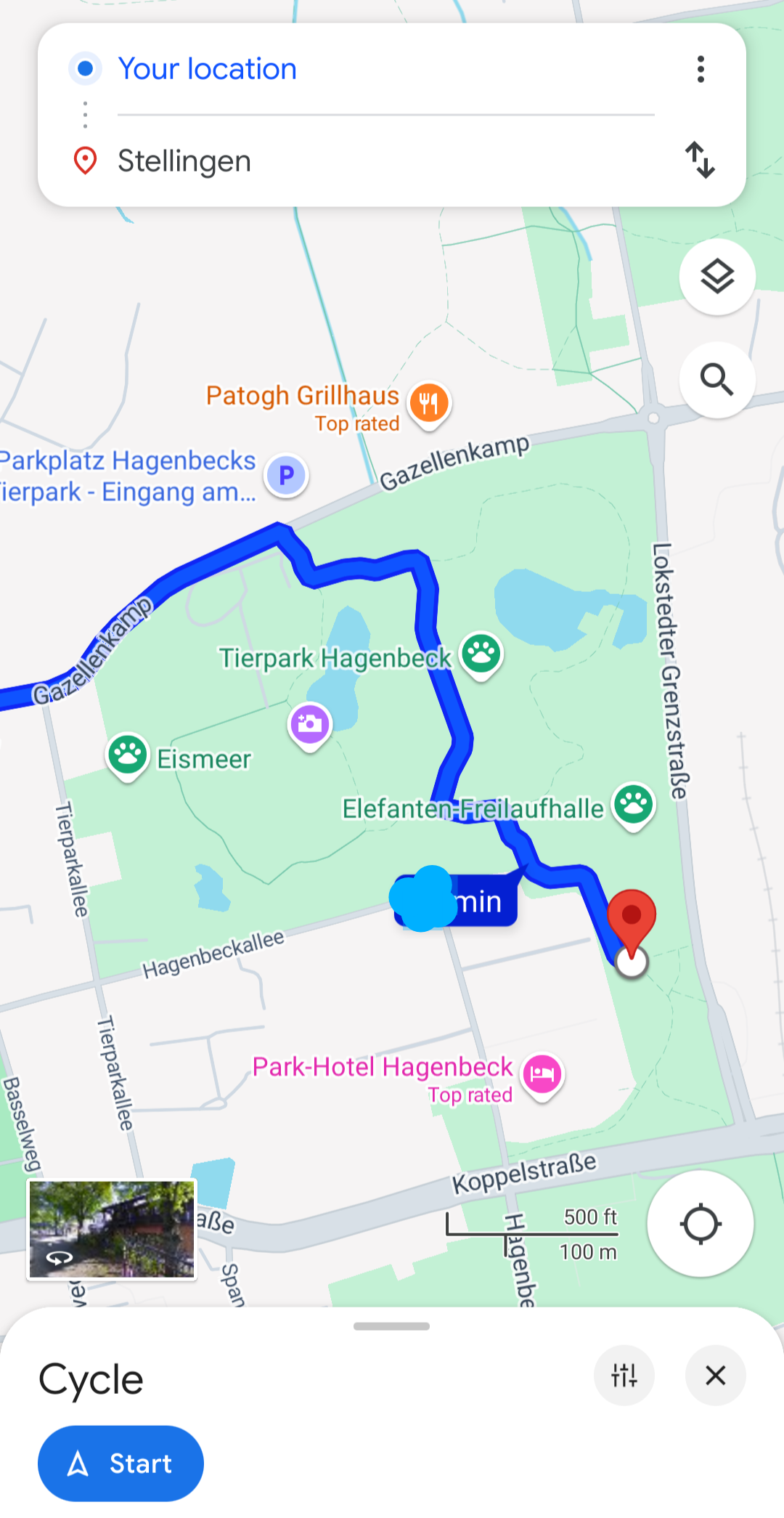
>Henry@hl@social.lol > > Glad to see the great job @openstreetmap and @organicmaps are doing. For cycling to the zoo's main entrance, where I can buy entry, they suggest a sensible route. #Google maps seems to suggest I go through the zoo, possibly via the tiger cage. > >https://social.lol/@hl/113047359789803891
>Dawid Rejowski@didek@101010.pl > >@hl @openstreetmap @organicmaps > >Also somehow ZOO looks more like a ZOO. > >Here I needed a while to understand what is that place. Only after reading the labels I understood it is the center of Warsaw, a place that should be one of the most recognizable places in Poland.\ >Compared to OragnicMaps, with rich colors, colorful Metro icons, building shapes and rails, Google Maps looks very blended. > >https://101010.pl/@didek/113050389244877936
-
I've got a patio for a restaurant tagged as leisure=outdoor_seating. That page says you can add
operator=*as a string, but I'm wondering if I can add a Relation between the patio and the restaurant. This is really for semantic reasons, because if the restaurant changes its name or gets a new owner, it would be nice if the patio didn't then have out-of-date information.I don't see a Relation type that's relevant. I don't want to just start doing my own thing, so does anyone know of a way to use a Relation here, and if not, is that something that can be proposed?
Thanks for all of the responses on my other questions, btw. This community has been very helpful.
I'm taking a look at traffic circles like this:
https://www.openstreetmap.org/edit#map=19/33.790043/-118.142392
The main traffic circle has been split up into 8 different segments, so that individual segments can have Relations added to them, such as the "Long Beach Transit 174" bus route. I'm new to mapping, so I don't really know what to expect, but it seems odd to split it up like that. It ends up adding noise to StreetComplete, in that I can't just say "yep, this traffic circle is asphalt", I have to go to a bunch of tiny segments and mark each one of them as asphalt.
I've also seen this for items generated from Lyft data, where a single road gets split into tiny segments so that one part can be marked as "no u-turn" or "no left turn". StreetComplete wants me to mark each tiny segment individually.
I'm looking to tag a simple 4 way stop with typical US red/yellow/green traffic signals. I was wondering what the difference between
signalandtraffic_lightsis in iD, and the wiki page just says this abouttraffic_lights:> A typical traffic signal. This value was the second most common value as of 2021-09-15 despite being undocumented until that point.
Looking at the talk page there, it links to this post, where an iD dev seems rather annoyed at the wiki:
> I took a look at https://wiki.openstreetmap.org/wiki/Key:traffic_signals and now I'm furious. > > Forget it. > > There is no way I'm going to support traffic_signals=yes for pedestrian signals, after the wiki folks aren't even ok with iD using traffic_signals=signal for a normal traffic signal - a tagging that was accepted just not very widespread before iD started doing it. > > The OSM Wiki needs to end. Seriously. It's ruining this project.
I'm using iD, so should I just leave it as the default
signalsand leave the fighting up to the devs? As an aside, does anyone know why there seems to be so much animosity there? Kind of surprising TBHI've encountered a bus stop that still exists, but has a sign from the city saying that no busses stop there. There's the disused tag on the wiki which seems relevant, but I'm not sure how to tag it exactly. There's lots of tags like
ref,route_ref,operator:wikidataand so on. Should all of those tags get prefixed withdisused:?was ist denn heute mit #Openstreetmap los? Läd das nur bei mir nicht bzw. nicht richtig?
What's going on with #Openstreetmap today? Is it just me that it's not loading or not loading properly?
\#osm @openstreetmap@en.osm.town @openstreetmap@lemmy.ml @osm\_tech
I'm trying to correct local buildings on OSM. I've noticed that some of the buildings were traced before according to one set of satellite images, but are off according to others. One of the options for a background while editing that I've got is called orthoimagery. Can I assume that that is the best set of satellite images for tracing buildings from?
I've tried Magic Earth a handful of times, but each time I dumped it because it marked a street as closed or wrong-way, creating a circuitous detour. There's no such issue in OSM; it simply hallucinated something.
I was testing it so I knew where I was going, but I'm reluctant to rely on it when I really need nav. Have I been supremely unlucky?
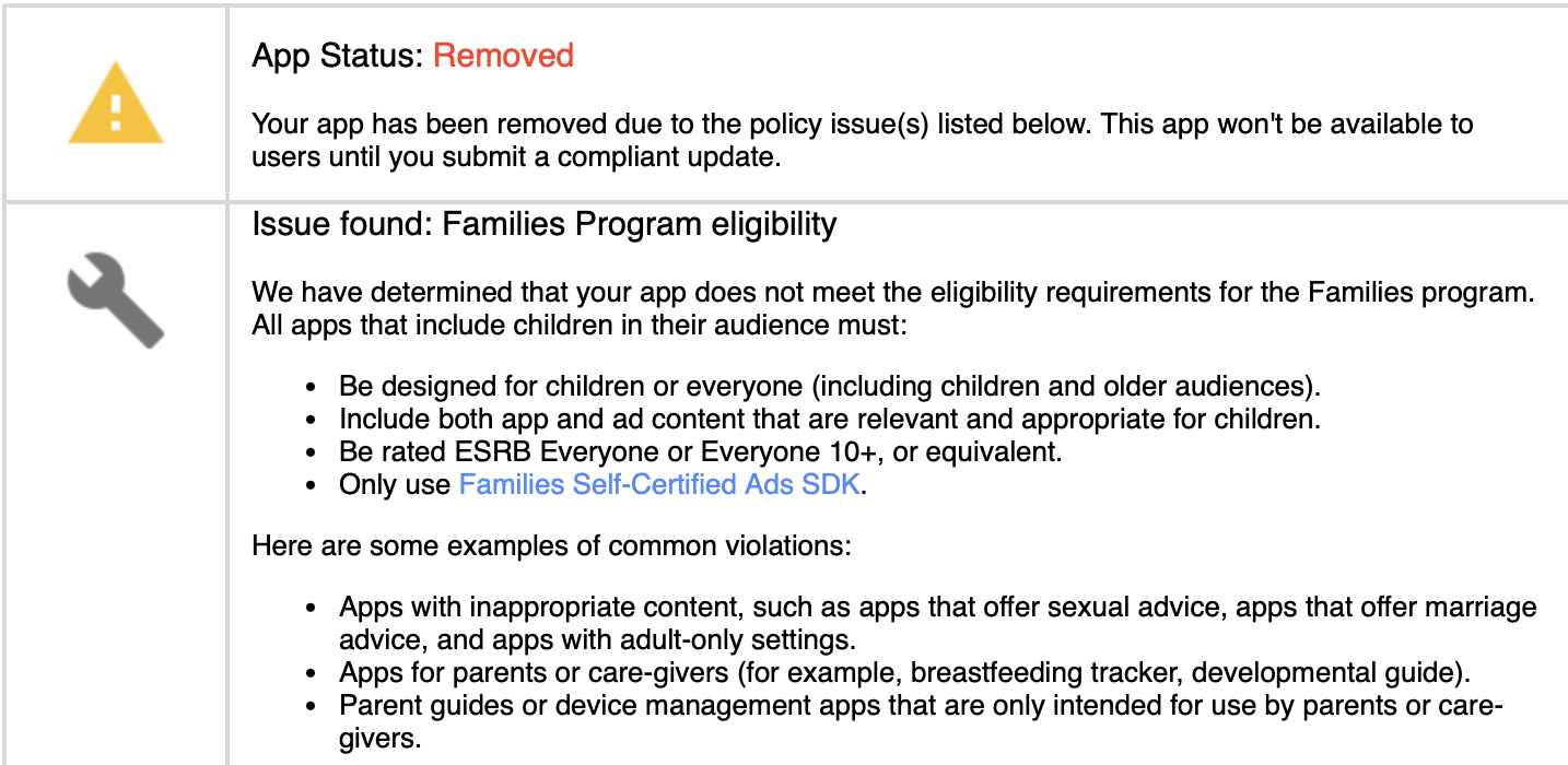
- fosstodon.org Organic Maps (@organicmaps@fosstodon.org)
Attached: 1 image Last night Organic Maps was removed from the Play Store without any warnings or additional details due to "not meeting the requirements for the Family Program". Compared to Google Maps and other maps apps rated for 3+ age, there are no ads or in-app purchases in Organic Maps. We h...
I've decided to tackle an indoor shopping mall near me. This will be shops within a larger structure, walking paths, and other features. Is there a guide anywhere for doing this correctly?
I just started "playing" Street Complete and noticed there was no way to add stuff like new bemches amd trash cans to the map. I found the "create note" feature and started using that for this purpose.
Before I continue like thisI just wamted to check with you guys and see; Am I doing this right?
https://www.openstreetmap.org/user/Hannes%20Knutsson/notes
I made some note about a new trash can, some new bench and some new stairs.
Do you only contribute what is useful for your own use cases, or whatever you can improve the map with?
- github.com organicmaps/docs/EXPERIMENTAL_PUBLIC_TRANSPORT_SUPPORT.md at master · organicmaps/organicmaps
🍃 Organic Maps is a free Android & iOS offline maps app for travelers, tourists, hikers, and cyclists. It uses crowd-sourced OpenStreetMap data and is developed with love by MapsWithMe (MapsMe)...

cross-posted from: https://lemmy.ca/post/26353596
> https://github.com/organicmaps/organicmaps/blob/master/docs/EXPERIMENTAL_PUBLIC_TRANSPORT_SUPPORT.md > > > HN Discussion](https://news.ycombinator.com/item?id=41152559)
I have always been real good about ensuring my business and the surrounding businesses (and other locations) are up to date in Apple, Bing, and Google Maps. I just started looking at OpenStreet Maps and see it has not been updated in over 3 years (and 2 locations ago). I updated the address, but the marker did not move. I do not see a way to move the marker to the correct location.
I am guessing I need to move all of the info (most of it is inaccurate) to where my business is currently located and then mark the old location as closed, or is there a better way to do that?
For some reason despite not owning one I have alot of interaction with Canal Boaters.
They are always interested in information about places and services along canals and I was trying to think of the best way of explaining how the contribute and use Openstreetmap
Of course contributing is easy - I just recommend mapcomplete.org, everydoor app, and street complete (less so as its road related)
And then I recommend an App like OSMAnd to use Openstreetmap - But for Canal Boaters specifically - Is there any way they could use layers or searches, any tips, tricks or Apps specifically get information that would be useful for them or be useful if in a canal boat?
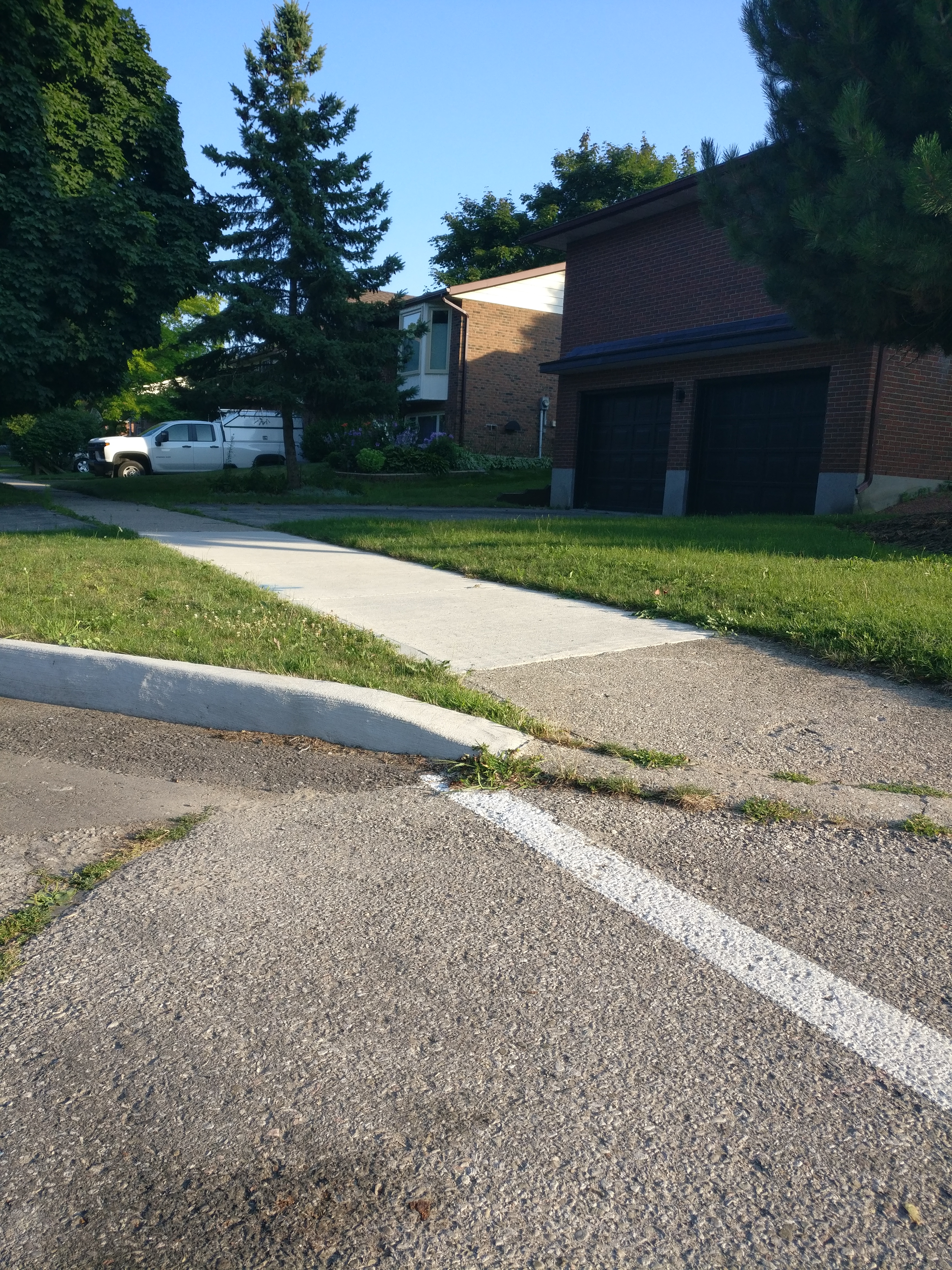
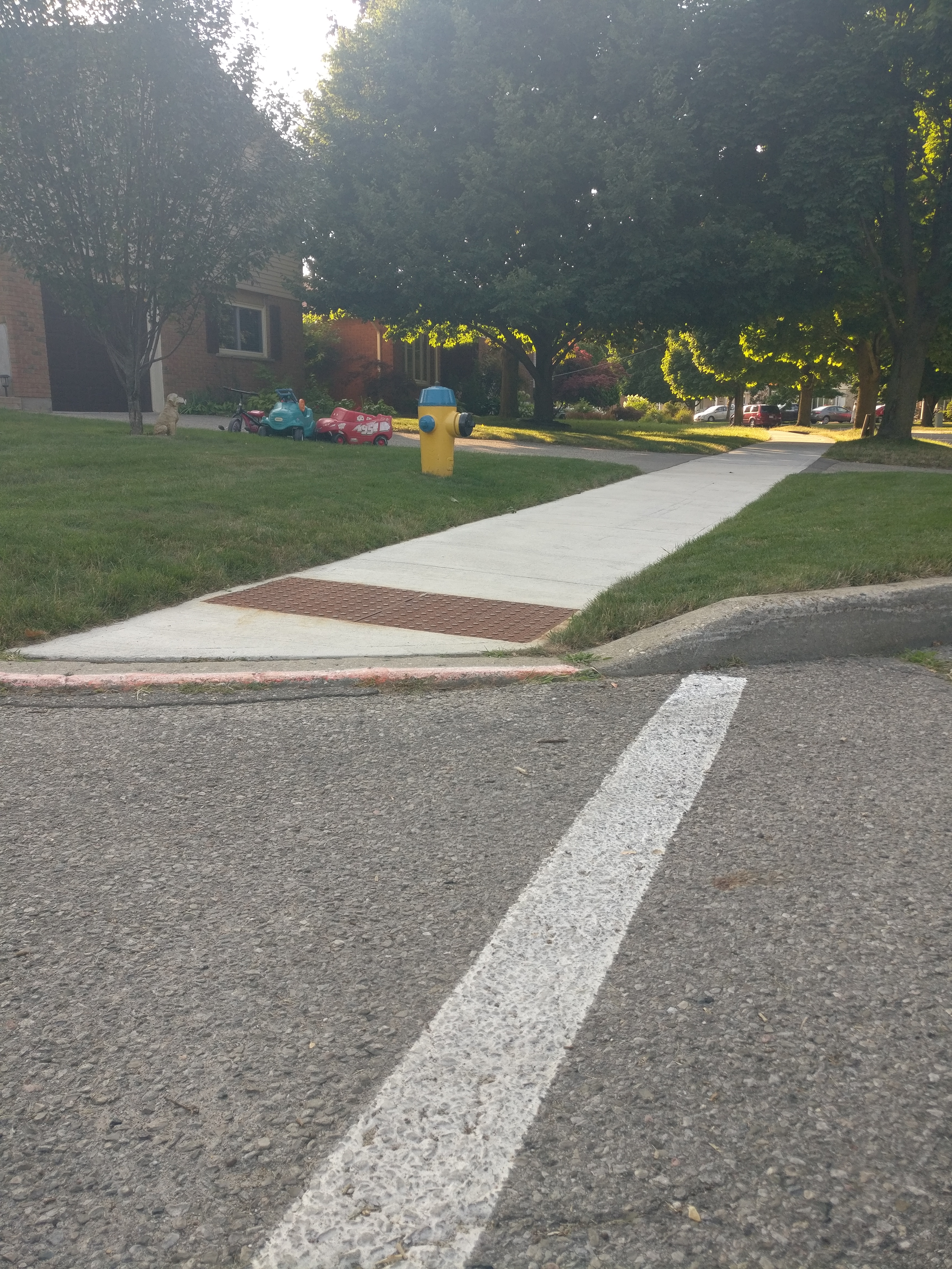
Hello! I've just started using StreetComplete, and I want to make sure I understand the answers before I go through and make a bunch of garbage data.
In this picture, is the kerb a ramp, or flush?
The sidewalk deflects downwards, but it's not a ramp ramp like the example picture.
How about this one?
The kerb itself dips, but the sidewalk on this one looks more flat and does simply run into the road. And then it has the texture, obviously. Is this one different from the last one?
Also, just to check, I marked both of these sidewalks as "concrete". That's correct, right? I wondered about "concrete plate", because they're segmented, but the picture made concrete plate look much more substantial.
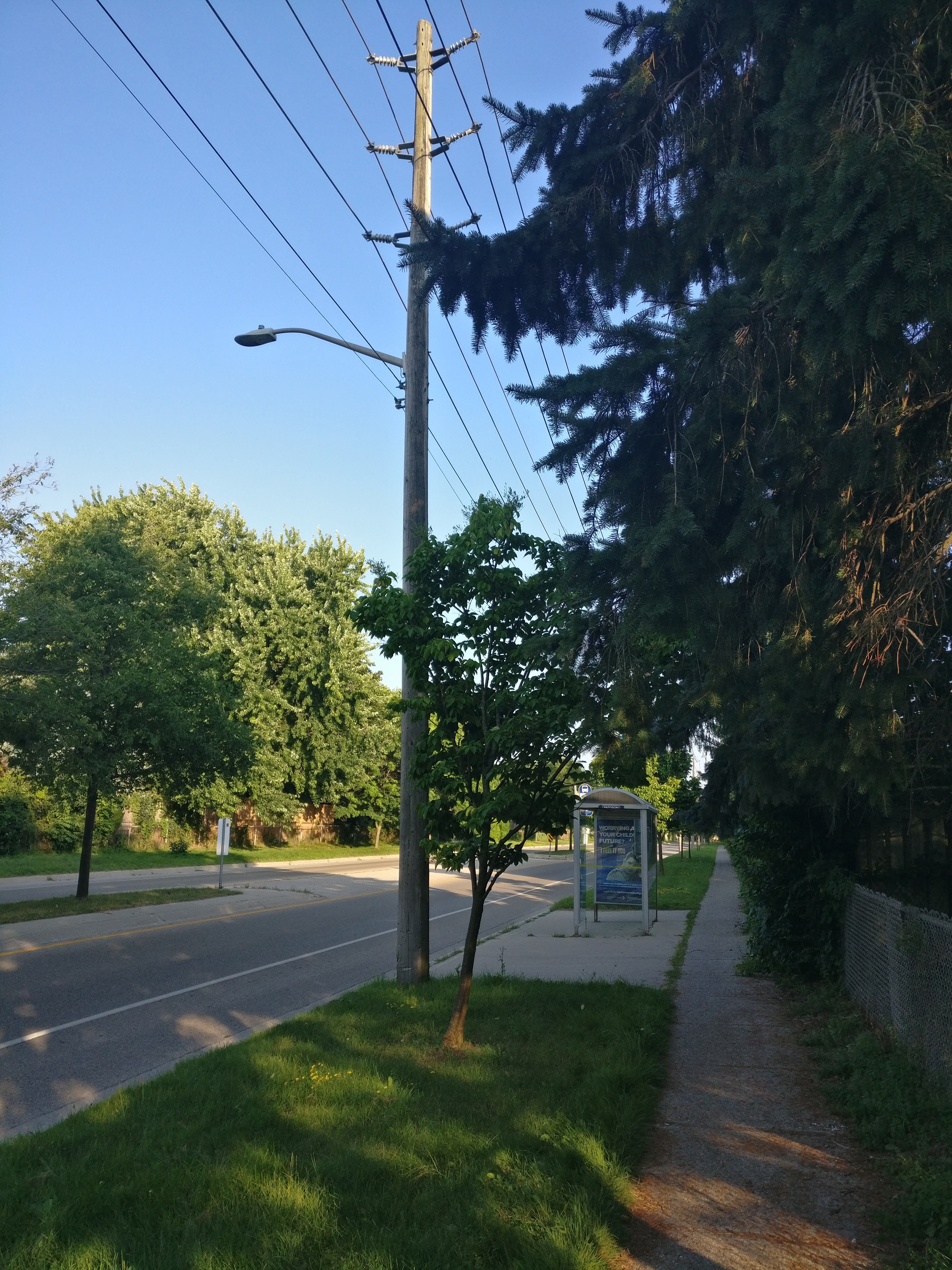
My other question was based on the "lit" tag for a bus stop. This bus stop has a street light near it, but there's no light on the bus stop itself. It sounds like that means it is lit? Would a non-lit stop just be one that is fully dark at night, then, with no kind of lighting anywhere near it at all?
This one is further from the street light, but still has line of sight. Lit?
Thanks very much for any help you have!
I've been contributing to Google Maps for a while, specifically, I usually upload pictures of menu's from restaurants, so future visitors can see them before they decide to eat there! I'm trying to degoogle my life a bit & was wondering if there is a way I could contribute these to OSM?
It hasn't been a week since I met OSM and Osmand. And I created all the beaches in a city from scratch. I added the important points in detail with their labels. I took long walks and it was fun.
I first learned of Street-Complete here and I really like it.
It's satisfying to walk around, complete little tasks, and get prizes, scratching a similar itch to Pokemon Go.
Stuck waiting for someone? Add opening hours for a few local businesses.
Have a long walk ahead of you? See if you can add/check house addresses as fast as you can walk.
Want to walk off a few beers before heading home? Complete some tasks in the bar street.
Its a very constructive way to "be right" on the internet.
is there a routing app/ service for canoes?
Edit: I ended up using brouter or osmand depending on the task.
Useful links for tracking this issue:
- Mastodon thread started by @geospacedman
- Mastodon thread started by OSM Ops Team
- Down for Everyone or Just Me
Edit: Viewing and editing functionality seem to be restored.
The main challenge with filling in neighborhoods is adding the addresses.
Adding the buildings is not so bad if the houses are mostly rectangles and only a couple sizes; copy/paste is pretty quick. Labeling other properties is similarly straightforward. However, adding hundreds of unique addresses is prohibitively tedious! I currently have to click on a single house, click on the address field, check the address, enter the address, then repeat for the next house. This is not so bad until it's repeated 100s (or 1000s) of times.
PLEASE tell me I'm just being foolish and there is an easy way to scroll through multiple selected buildings to enter the same field in each! I'm picturing something like: select all houses, enter first address, HOTKEY TO NEXT HOUSE, enter next address. Not only would it remove several steps, but also remove manual mouse clicks which require diverting attention. If I could do this, I could have a list of addresses and zip through an entire area pretty quickly without losing my place constantly looking back and forth.
I need some help @openstreetmap.
UPDATE: Thanks for all the help!
What do I do, if a business has closed down, and then a new business has taken over the same place?
Do I mark the previous business as “does not exist” and add the new one, or do I edit the existing one?
- beta.nyc What’s New at State of the Map US 2024? - BetaNYC
The Fellowship team attended State of the Map US 2024 at Salt Lake City! Learn about the workshops they attended and what trends they noticed within the open-sourced mapping world.

